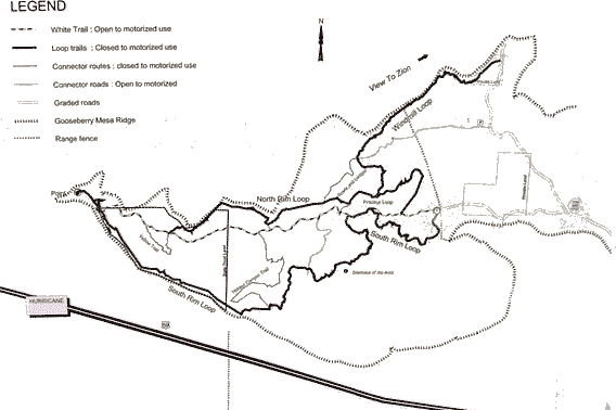
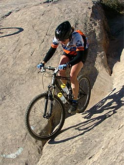
Gooseberry Mesa is a big mesa northeast of St. George and east of Hurricane. There is a wide variety of awesome riding on the mesa in a network of trails that all loop off the doubletrack (the "White Trail" that runs down the center of the mesa. You'll find, sometimes on the same trail: slickrock, twisty singletrack, sandy doubletrack, river rock (it's amazing to think that the top of the mesa was underwater at some point!) and more.
The mesa can be accessed from
Gooseberry Mesa is a tabletop mesa just west of Zion National Park with a world-class trail system combining slickrock stunts and singletrack. The South Rim slickrock areas are advanced-level technical. In God's Skateboard Park, you'll find stunts ranging from the merely difficult to the truly insane. The North Rim Trail is intermediate technical -- for the beginner, Slickrock 101 features easier slickrock and singletrack. There's little altitude change overall -- no long brutal hill-climbs. There are also undeveloped camp sites all along the Gooseberry Mesa Road.
Getting there - Recommended
From I-15, take the Hurricane Highway exit and merge to the right on Highway 9. In the town of Hurricane, turn right at the Highway 59 sign. One block later, turn left and drive out of town towards Kanab. About 15 minutes later, you will pass a gas station on the left-hand side, then some fields. Watch for a "Scenic Byway" sign 14.8 miles from the turnoff in Hurricane between
mile marker 8 & 9, and turn hard left onto a dirt road. Two miles later, just as you reach juniper trees, the Gooseberry Mesa road turns off on your left. . 3.6 miles after this turnoff, fork left at the outhouse. Now ignore any smaller branching roads. 1.1 miles later, you'll cross a cattle guard. Park there. The trail begins along the fence on the left side.
Getting there - Alternate, from the North: (Be warned: This route is longer and prettier, but did damage to the underbelly of our Honda Accord because of how rutted out it was from people driving up there during wet weather.)
As you approach Zion National Park in Rockville, turn south (right) on Bridge Road. Continue straight until the road turns right (west) and turns to gravel. Keep left at the fork at 1.5 miles. At 6.2 miles, watch for a road going through the fence on your right at the top of the mesa. 3.6 miles after this turnoff, fork left at the outhouse. Now ignore any smaller branching roads. 1.1 miles later, you'll cross a cattle guard. Park there. The trail begins along the fence on the left side N 37¡ 08.500 W 113¡ 10.300'
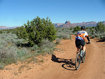
Only since the late 1990's has Southwesten Utah been considered a destination for Mountain Bikers. In their short existence, however, the reputation of our trails, especially those here on Gooseberry Mesa, have become known the world over.
The Gooseberry trail was created by two brothers from the Hurricane Valley, Mike and Morgan Harris. They first discovered the slickrock patches in 1993 and began exploring them on "pedal" bikes. As their expertise in technical riding increased, the slickrock playing adjacent to the Jeep trail became less challenging and they began to look for ways to connect the patched to create a trail.

As word spread, the mesa was discovered and explored by many other local mountain bikers. So in 1996 Mike and Morgan presented the idea for a mountain bike trail to the Bureau of land Management and several meetings were held with the bike community and interested parties to assure commitment and support for the project. The BlM approved the trail in May of 1998.
At the time the approval process began, Gooseberry Mesa trail was known mainly by locals. Its popularity today, however, can be attributed to its excellent trail design, the promotion of the area by local riders and merchants, and the continued support by local community members. BLM would like to thank Mike and Morgan Harris for their long time dedication to this project, Bike Zion for their assistance with the windmill connector trail and trail descriptions, and all the many volunteers who have worked hard to install and maintain signing and trail markings, and for monitoring conditions to maintain a safe and enjoyable riding experience.
--TRAIL MARKINGS In an attempt to find a method of marking that was unintruslve to the natural setting yet fulfilled the need to clearly guide riders through the maze of loops, many different trail marking shapes and colors were investigated. The trail officially is now marked in a reflective light color dot. Old trail markings may still be encountered while riding the trail and may vary from dark green to light blue or long white stripes. As they fade they are replaced.
To avoid getting lost, please only follow the white dot markings as variations to the trail have occurred since Its original creation.

Gooseberry Mesa trail is a technical riding trail that is actually a series of interconnecting loops that allow the rider to customize the length and technical difficulty of the ride. The trail was originally designed to do as a clockwise loop, however, each component of the trail can be ridden in any direction. Because of the angle and slope of the mesa, riding away from the point is considerably less difficult than going up. This design format allows the rider the opportunity to combine loops, customizing a trail to suit interest or ability.
-- WHITE TRAIL. This trail is actually an old Jeep trail and is the only portion that remains open to motorized vehicles. The trail is 3.5 miles in length and is an "out and back" to the POINT. This portion of the trail is rated beginning technical and is considered the easiest ride on the Mesa. It can also be used to access middle portions of the rim trails or as a quick return to the parking area.
- THE PRACTICE LOOP. Just a short ride from the parking area you will find the PRACTICE LOOP. This loop is actually part of the NORTH RIM LOOP. Although this loop is rated intermediate technical. it is the easiest portion of the single track and is highly recommended for those who have not ridden single track or slickrock.
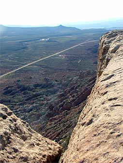
- THE SOUTH RIM LOOP. This loop begins at the parking area and is considered a difficult advanced technical ride. Expect exposure to steep drop-offs, difficult climbs, sharp turns, and narrow ledges. Use caution when riding along the rim.
- THE NORTH RIM LOOP. This loop is rated intermediate technical. Beginning from the east end the loop gets steadily more difficult toward the point. Expect narrow ledges along the rim and various chutes and domes.
- WINDMILL LOOP. This loop is a good intermediate loop that is just under 4 miles in length. The trail features some of the best views of Zion National Park. The road portions of this trail are open to motorized vehicles.
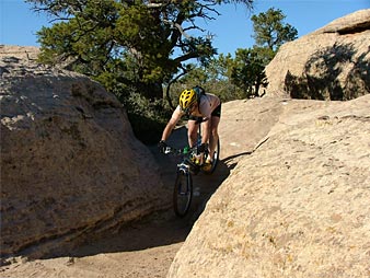
- THE YELLOW TRAIL. This trail can be used as a bypass to the sand pit. The sand pit is about 180 yards long and 4-6 inches deep. The trail is about one half mile long and by far the most difficult and technical with one obstacle after another.
- HIDDEN CANYON. Appropriately named, this stretch connects the SOUTH RIM LOOP to the WHITE TRAIL via BLM lands. The trail takes you into some hidden worlds of the mesa. The trail is advanced technical, but worth the work. It truly takes the rider into a place of beauty and solitude, riding past wild flowers, through thick stands of vegetation and under ledges. Keep your eye on a feature to keep from getting disoriented in this trail maze.
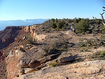
- BOWLS AND LEDGES. This is a short trail of intermediate difficulty that connects the PRACTICE LOOP to the WINDMILL LOOP and back to NORTH RIM LOOP. Obstacles include rock ledges that riders enjoy doing wheelies on, and a fun bowl and dome slickrock patch.
-- CONNECTOR ROADS There are two sections where other existing jeep roads are used to connect portions of trail. It should be noted that these routes are open to all vehicles.
-- NO MOTORIZED TRAVEL. Except where Posted, this Trail Is Closed to Motorized Travel. Use Caution When Passing a Vehicle on the White Trail or Windmill Loop.

- STAY ON DESIGNATED TRAILS. The desert environment Is fragile and cutting trails destroys vegetation and degrades soils, It can also contribute to trail confusion.
- PACK IN PACK OUT. Please take home what ever you bring, trash service is not available. If you see trash left by others, pick it up. The trail can only stay clean with everyone's help.
- DON'T HARASS LIVESTOCK. Grazing sometimes occurs on the mesa. Please be considerate of livestock and other wildlife you may encounter while riding.
- KNOW YOUR LIMITS. All users should be prepared for the elements and know their abilities. Trail difficulty markings shoukl be noted by all. Be aware that lightning and sudden storms can occur. Rocks are better shelters than trees. Know your way back to your vehicle in case of an emergency.
- SHOW TRAIL ETIQUETTE. While this trail was designed by mountain bikers for mountain bikes, the trail is open to all non-motorized users. Mountain bikers should practice proper trail etiquette by yielding to horses and hikers.